
Introduction
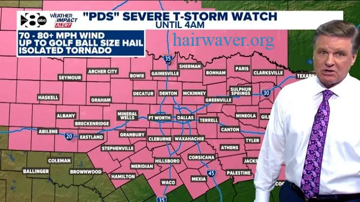
Your phone screams. A bright red alert fills the screen. The words “PDS Severe Thunderstorm Watch” appear in bold. Your first reaction is probably to wonder whether this is worse than a regular watch and exactly how seriously you should take it.
The short answer is: take it very seriously. A PDS severe thunderstorm watch is not routine. It represents one of the most dangerous weather situations the National Weather Service can flag before a storm event. PDS stands for Particularly Dangerous Situation, and that label gets used rarely and deliberately.
This article explains everything you need to know about a PDS severe thunderstorm watch. You will learn what PDS means, why it differs from a regular thunderstorm watch and a warning, how long these watches typically last, what actions you should take, and which states see these events most frequently. Whether you live in Texas, Oklahoma, Kansas, Nebraska, or Missouri, understanding this alert could genuinely save your life.
What Does PDS Mean in a Severe Thunderstorm Watch?
Direct Answer: PDS stands for Particularly Dangerous Situation. A PDS severe thunderstorm watch is issued by the Storm Prediction Center when meteorologists expect an outbreak of severe thunderstorms with an exceptionally high likelihood of producing significant tornadoes, very large hail, or destructive winds far beyond what a standard watch covers.
The National Weather Service and the Storm Prediction Center issue severe thunderstorm watches regularly during active weather seasons. A standard severe thunderstorm watch tells you that conditions are favorable for severe storms. A PDS severe thunderstorm watch goes significantly further. It signals that the atmospheric conditions are primed for an exceptional, high-end severe weather event.
The PDS designation is not applied casually. Meteorologists use it when multiple atmospheric factors combine to create an unusually threatening setup. You will not see this label on every stormy day. When you do see it, the weather team has identified a situation that demands your immediate attention and preparation.
Is a PDS Severe Thunderstorm Watch Dangerous?
Direct Answer: Yes. A PDS severe thunderstorm watch is significantly more dangerous than a standard severe thunderstorm watch. It indicates a high probability of multiple significant severe weather events occurring across a broad geographic area.
The danger level during a PDS severe thunderstorm watch is elevated for several specific reasons.
First, the storms expected under a PDS watch are more likely to produce significant tornadoes rather than just damaging winds and hail. Not all severe thunderstorms produce tornadoes. PDS events have a much higher tornado probability baked into the forecast.
Second, hail sizes during PDS events can be extraordinary. While a standard severe thunderstorm watch might involve one-inch hail, a PDS event can produce hailstones ranging from two to four inches in diameter. Hail at that size causes serious structural damage to vehicles, roofing, and windows and can injure or kill livestock and people caught in the open.
Third, the wind gusts associated with PDS-level thunderstorms frequently exceed 70 to 80 miles per hour. That is hurricane-force wind. Straight-line winds at that speed destroy trees, power lines, mobile homes, and poorly constructed structures.
The combination of tornado risk, extreme hail, and destructive winds makes a PDS severe thunderstorm watch one of the most urgent weather alerts the system produces.
What Is the Difference Between a PDS Watch and a Warning?
Understanding the difference between a watch and a warning is just as important as understanding what PDS means. People frequently confuse the two and either over-react or under-react as a result.
Severe Thunderstorm Watch
A severe thunderstorm watch tells you that conditions in your area are favorable for severe thunderstorms to develop. The storms have not necessarily started yet. You have time to prepare. This is the moment to check your emergency supplies, know your shelter location, and stay tuned to local weather coverage.
A PDS severe thunderstorm watch escalates this level of urgency significantly. The same pre-storm window applies, but the expected storms are far more threatening than typical. Use every minute of this window to prepare thoroughly.
Severe Thunderstorm Warning
A severe thunderstorm warning is issued when a severe thunderstorm is occurring or is imminent based on radar or ground confirmation. This means the storm is happening right now. Take shelter immediately. A warning leaves no time for preparation. You must act the moment you receive it.
Quick Comparison Table
| Alert Type | Meaning | Action Required |
|---|---|---|
| Standard Severe Thunderstorm Watch | Conditions favorable for severe storms | Prepare and stay alert |
| PDS Severe Thunderstorm Watch | Conditions favorable for exceptionally dangerous storms | Prepare urgently, stay close to shelter |
| Severe Thunderstorm Warning | Storm is occurring or imminent right now | Take shelter immediately |
| Tornado Warning | Tornado confirmed or indicated by radar | Move to lowest interior room immediately |
What Should You Do During a PDS Severe Thunderstorm Watch?
Direct Answer: During a PDS severe thunderstorm watch, you should immediately prepare your shelter, gather emergency supplies, monitor local weather continuously, and be ready to move to safety the moment a warning is issued.
Do not wait for a warning to start preparing. The window between a PDS watch and the first warning can be very short. Here is what to do the moment you receive a PDS severe thunderstorm watch alert:
Immediate Actions
- Move vehicles into a garage or covered structure if possible. PDS-level hail destroys vehicle exteriors and shatters windshields.
- Charge your phone fully. Power outages during severe weather are common. You need your phone operational to receive alerts.
- Identify your safest shelter location in your home. The lowest floor, an interior room without windows, is your best option.
- Gather essential supplies including water, flashlights, a battery-powered weather radio, and any medications.
- Bring pets and outdoor animals indoors immediately. Animals cannot protect themselves during extreme hail or tornado conditions.
- Cancel any outdoor plans. This is not the day for an outdoor event, a long drive, or yard work that puts you exposed.
Stay Informed
Tune into a NOAA weather radio, local television news, or a reliable weather application. During a PDS severe thunderstorm watch, the Storm Prediction Center and your local National Weather Service office will issue frequent updates. These updates tell you which counties are under the greatest immediate threat and when the watch may be upgraded.
Be especially alert to any tornado warnings that get issued within an active PDS watch. The upgrade from a PDS thunderstorm watch to a tornado emergency can happen in minutes during an active severe weather outbreak.
How Long Does a PDS Severe Thunderstorm Watch Last?
Direct Answer: A PDS severe thunderstorm watch typically lasts between four and eight hours, though the Storm Prediction Center can extend or cancel it based on how actual storm development compares to the forecast.
The watch area itself covers a broad geographic region. You might be in the watch area for many hours before any storms approach your specific county. During that window, you remain on alert and ready to act quickly when conditions deteriorate near you.
Watches are cancelled early if storm development underperforms the forecast. They are extended if the threat persists longer than originally anticipated. Monitor your local National Weather Service office updates to track any changes to the watch duration.
States Where PDS Severe Thunderstorm Watches Occur Most Often
The geographic areas most prone to PDS severe thunderstorm watches align directly with the regions where atmospheric conditions most regularly combine to produce extreme severe weather outbreaks.
Texas
Texas experiences PDS severe thunderstorm watches more than almost any other state. The combination of Gulf moisture surging northward, dry air from the southwest, and strong jet stream dynamics creates an almost ideal severe weather factory across the plains of central and north Texas. The Dallas-Fort Worth metroplex and the Texas Panhandle see particularly frequent high-end severe weather events.
Oklahoma
Oklahoma sits at the epicenter of Tornado Alley and experiences PDS watches during its most active spring weather seasons. The state’s flat terrain allows storms to develop and organize rapidly without geographic obstacles to disrupt their structure. Oklahoma City has been struck by significant tornadoes multiple times and remains one of the most tornado-vulnerable metropolitan areas in the country.
Kansas
Kansas sees frequent PDS severe thunderstorm watches each spring. The wide, open plains of central and western Kansas allow supercell thunderstorms to develop and travel enormous distances while maintaining their intensity. Wichita and surrounding communities in south-central Kansas experience some of the highest concentrations of significant severe weather in the nation.
Nebraska
Nebraska’s location at the northern edge of the Great Plains places it squarely in the path of organized severe weather outbreaks. The storm systems that develop over Kansas and Oklahoma frequently push northeast into Nebraska, bringing PDS-level conditions with them. The southwestern corner of the state around North Platte and the Kearney area see some of the most intense activity.
Missouri
Missouri bridges the gap between the core of Tornado Alley to the west and the broader severe weather region of the mid-Mississippi Valley. Springfield, Joplin, and Kansas City have all experienced catastrophic severe weather events within the last two decades. Missouri sees PDS watches primarily in spring but can experience dangerous severe weather events from April through October.
How to Receive PDS Severe Thunderstorm Watch Alerts
You should have multiple ways to receive severe weather alerts before a PDS severe thunderstorm watch event. Relying on a single source creates risk if that source fails or you are not near it when conditions deteriorate.
Set up these alert systems:
- Wireless Emergency Alerts: Your phone receives these automatically if your carrier supports the system
- NOAA Weather Radio: A battery-powered unit works during power outages and covers your specific county
- Local television and radio: Storm teams provide continuous coverage during active severe weather
- Weather applications with push notifications: Enable severe weather alerts for your current location and home location
Conclusion
A PDS severe thunderstorm watch is the weather system’s way of telling you that something genuinely significant is coming. It goes beyond routine severe weather preparation and demands that you treat the incoming event with the highest level of seriousness. PDS events in Texas, Oklahoma, Kansas, Nebraska, and Missouri account for some of the most damaging and deadly weather outbreaks the United States experiences each year.
Preparation during the watch window is your greatest advantage. Move vehicles, charge devices, identify shelter, gather supplies, and monitor continuously. When the warnings start dropping, you will be ready to act immediately rather than scrambling.
Have you ever experienced a PDS severe thunderstorm watch in your area? Share your experience in the comments and let us know how you prepared. Your story might help someone else take this alert seriously when it counts most.
FAQs About PDS Severe Thunderstorm Watch
1. What does PDS mean in a severe thunderstorm watch? PDS stands for Particularly Dangerous Situation. The Storm Prediction Center adds this label when meteorologists expect an outbreak of severe thunderstorms with an unusually high probability of producing significant tornadoes, very large hail, destructive winds, or a combination of all three.
2. Is a PDS severe thunderstorm watch dangerous? Yes, significantly more dangerous than a standard severe thunderstorm watch. PDS watches indicate a high probability of significant tornadoes, hail exceeding two inches in diameter, and wind gusts above 70 miles per hour across a broad area.
3. What is the difference between a PDS watch and a warning? A PDS watch means dangerous conditions are favorable and storms have not necessarily started. A warning means a severe thunderstorm is occurring or imminent right now. Prepare during the watch. Take shelter immediately when a warning is issued.
4. What should I do during a PDS severe thunderstorm watch? Move vehicles to shelter, charge your phone, identify your safest interior room, gather emergency supplies, bring pets indoors, cancel outdoor plans, and monitor weather updates continuously until the watch expires or is cancelled.
5. How long does a PDS severe thunderstorm watch last? Most PDS severe thunderstorm watches last between four and eight hours. The Storm Prediction Center can extend the watch if the threat continues longer than forecast or cancel it early if conditions improve.
6. Which states get PDS severe thunderstorm watches most often? Texas, Oklahoma, Kansas, Nebraska, and Missouri see the highest frequency of PDS severe thunderstorm watches due to their location in the heart of Tornado Alley where the atmospheric conditions most regularly produce extreme severe weather outbreaks.
7. Is a PDS watch the same as a tornado watch? No, but they are related. A PDS severe thunderstorm watch focuses on extreme thunderstorm conditions including hail and wind with elevated tornado probability. A tornado watch specifically highlights areas where tornadoes are likely to develop. PDS conditions frequently lead to the issuance of tornado watches or tornado warnings within the same area.
8. Can a PDS watch be upgraded to a tornado emergency? Yes. A PDS thunderstorm watch area can see a tornado warning or even a Tornado Emergency issued within it if an actual tornado develops and threatens a populated area. The watch and the warning operate as separate alerts serving different purposes.
9. Should I evacuate during a PDS severe thunderstorm watch? Evacuation is generally not recommended during a watch. Use the watch window to shelter in place, prepare your safe room, and monitor conditions. Evacuating by vehicle during active storm conditions can put you in far more danger than sheltering in a sturdy structure.
10. How do I receive PDS severe thunderstorm watch alerts on my phone? Enable Wireless Emergency Alerts in your phone settings to receive government-issued alerts automatically. Download a weather application and enable severe weather push notifications. Consider purchasing a NOAA weather radio as a backup for power outage situations.
Hair Waver Basics Step by Step
About the Author : Daniel Reeves is a certified meteorologist and weather safety educator with over fourteen years of experience covering severe weather patterns across the Great Plains and Central United States. He has worked alongside National Weather Service forecasters during active severe weather outbreaks and specializes in translating complex atmospheric science into clear, actionable guidance for everyday people. Daniel believes that understanding weather alerts saves lives. When he is not writing about severe weather, he volunteers with local emergency management agencies to train communities on severe weather preparedness.
email: johanharwen@314gmail.com
Author Name: Daniel Reeves